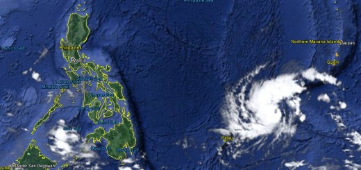
Tropical Storm NOUL

The Tropical Depression seen end of last week got stronger and better organized. Tropical Storm NOUL is currently moving slowly west-northwest. Japan Meteorological Agency predicts that Tropical Storm NOUL will become a typhoon category 1 within the next 2 days.
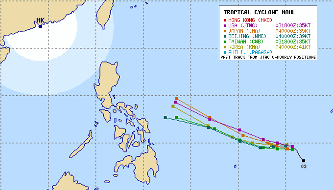
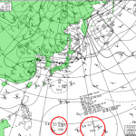
All forecast tracks run almost parallel. The different latitudes are due to the parameter weights of the low and high pressure areas over continental China.
At this very moment it is still difficult to determine a general behavior because weak low pressure areas can change their direction very quickly. This is well visible in the beginning of the track below.
Outlook
Tropical Storm NOUL will rapidly gain strength and continue moving towards the Philippines at a speed of 10 km/h. Circulating wind speeds will increase and TS NOUL will become a Typhoon Cat.1 tomorrow evening/night.
Cyclone NOUL is expected to arrive in the Philippines next weekend.
NOUL Storm data:
| Name (INTL. / local): | NOUL / — |
| Class: | Tropical Storm |
| Time/Date of observation: | 05:00 AM on May 24, 2015 |
| Location of Center: | 9.6º North 140.3º East |
| Moving Direction and Speed: | Northwest @ 05 km/h |
| Moving towards: | Philippine Islands |
| Distance from the Philippines: | 1,570 km ENE of Surigao |
| Estimated Date / Time of Landfall: | n/a |
| Max. Wind Speed near Center: | 65 km/h |
| Peak Wind Gusts: | 85 km/h |
| Minimum Central Pressure: | 998 hPa |
| Diameter: | 550 km |
| 24h Rainfall near Center: | 100 – 500 mm |
| Max. Wave Height: | 8 – 10 m |
| Here you find how to read and understand this data | |
Nearly real-time storm information
[GARD]
Related posts
 May 6, 2015 Cyclone NOUL almost Typhoon As predicted, Cyclone NOUL will be upgraded to a Typhoon Category 1 today. This might even happen a bit earlier. Central pressure went […]
- May 5, 2015 Tropical Storm NOUL getting stronger Tropical Storm NOUL is currently moving slowly westward. Japan Meteorological Agency predicts that Tropical Storm NOUL will become a […]
- July 24, 2014 2 Low Pressure Areas queuing up 2 Low Pressure Areas queuing up for the Philippines. The two LPAs 96W and 98W are slowly moving westwards. They are still weak with 1006 […]
- March 3, 2012 Pasaway Driver! What do you think? A few weeks ago, a reader of this blog sent us a link to his new website: Pasaway Driver! The initial idea isn't bad. We all have […]
- March 30, 2016 Kanlaon Volcano – Two Eruptions with ash fall Two minor eruption events occurred at Kanlaon Volcano at around 6:20 PM and 7:18 PM of 29 March 2016.
The eruptions lasted around 12 […]


Recent Comments