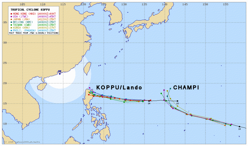
Tropical Storm KOPPU/Lando straight westward

Tropical Storm KOPPU/Lando continues on its westward track. It has slightly slowed down the forward speed from 25 to 20 km/h. It has maintained wind speed (strength).
Forecast
Tropical Storm KOPPU/Lando will continue to move on a generally westward track for the next 24 hours, turning slightly west-northwestward. It will intensify during the next 48 hours while moving over the warm waters of the Philippine Sea and will becoming a Typhoon by Thursday evening. The second Tropical Storm CHAMPI will turn northwestward very early and should not reach the Philippines.
PAGASA has not yet set storm signals. Tropical Storm KOPPU/Lando brings rain showers with some thunderstorms across the Northern and Eastern Sections of Luzon including Bicol and Quezon Provinces at least for the next 24 hours. Residents are advised to take precautionary measures against possible flashfloods and landslides especially during heavy downpour.
KOPPU/Lando Storm data:
| Name (INTL. / local): | KOPPU/Lando |
| Class: | Tropical Storm |
| Time/Date of observation: | 08:45 PM on October 14, 2015 |
| Location of Center: | 15.5° North 135.6° East |
| Moving Direction and Speed: | West @ 20 km/h |
| Moving towards: | Northern Luzon |
| Distance from the Philippines: | 1285 km E of Casiguran |
| Estimated Date / Time of Landfall: | Saturday |
| Max. Wind Speed near Center: | 75 km/h |
| Peak Wind Gusts: | 95 km/h |
| Minimum Central Pressure: | 996 hPa |
| Diameter: | 540km |
| 24h Rainfall near Center: | 100 – 500 mm |
| Max. Wave Height: | 5 m |
| Here you find how to read and understand this data | |
Nearly real-time storm information
Next update tomorrow around noon.
[GARD]
Related posts
 October 15, 2015 Tropical Storm KOPPU/Lando a bit slower Tropical Storm KOPPU/Lando advanced a bit slower than forecasts predicted. While still moving westward it gained a bit of strength. The […]
- November 18, 2015 Tropical Storm IN-FA moving west Tropical Storm IN-FA is moving west. This storm is still far away from the Philippines but has the potential to amplify to a Typhoon Cat. […]
- October 13, 2015 Two Tropical Depressions in a row Two Tropical Depressions in a row are approaching the Philippines. The nearer one at 142° E, is moving westward at 15 km/h. The second one […]
- July 8, 2015 CHAN-HOM and NANGKA – Habagat Amplifiers Last weekend, Tropical Storm LINFA/Egay brought a lot of rain over northern Luzon. Now it is enhancing the southwest monsoon (Habagat) […]
- October 6, 2014 Typhoons – still lucky Philippines Typhoon season 2014 started in April with Tropical Storm PEIPAH / Domeng. Since then already 17 cyclones crossed over the waters of the […]


Recent Comments