Super Typhoon HAGUPIT/Ruby – I stay with JMA

Super Typhoon HAGUPIT/Ruby – I stay with JMA. The battle between the typhoon track forecasters makes higher waves than the typhoon. After having viewed the latest isobar map from 11:00 a.m. (PST) and having seen the strong High Pressure Area over China, I stay with JMA’s forecast.
High Pressure Area over China
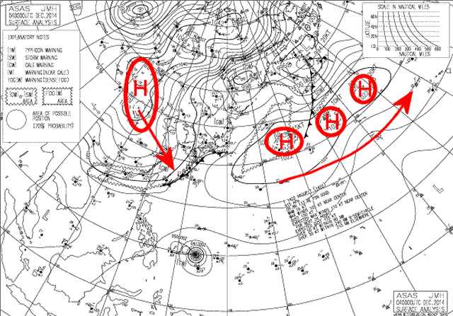
The large High Pressure Area (HPA) on the left has centres with pressures from 1042 to 1048 hPa. This strong HPA moves south-southeast at 11 kt = 20 km/h and makes pressure on Super Typhoon HAGUPIT/Ruby. This is the reason why I believe that the storm will JMA’s forecast track and cross over the central Visayas.
[Remark:] This is not a religious believing. If somebody has stronger arguments than JMA, I change within seconds.
Clouds show High Pressure over China
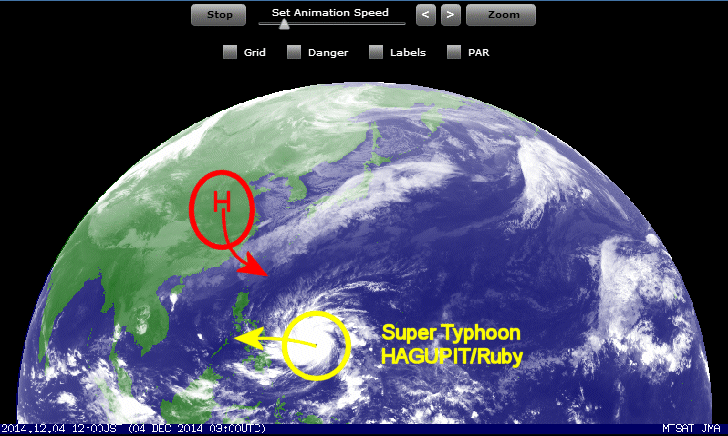
Our 24 hours satellite loops show how the “Chinese” High Pressure Area pushes the clouds south-southeast. The final track of HAGUPIT/Ruby is a race between the two Pressure areas. The typhoon moves at 30 km/h west-northwest and the Chinese High moves at 20 km/h south-southeast. The satellite images are updated once per hour.
Check the animated satellite pictures. It is really a thriller what happens in the atmosphere just now.
The JMA track forecast
Super Typhoon HAGUPIT/Ruby Storm data
| Name (INTL. / local): | HAGUPIT/Ruby |
| Class: | Super Typhoon Cat.5 |
| Time/Date of observation: | 09:00 AM on December 4, 2014 |
| Location of Center: | 9.8º North 133.8º East |
| Moving Direction and Speed: | West – Northwest @ 30 km/h |
| Moving towards: | Leyte / Samar |
| Distance from the Philippines: | 975 km E of Surigao |
| Estimated Date / Time of Landfall: | Saturday / Sunday |
| Max. Wind Speed near Center: | 220 km/h |
| Peak Wind Gusts: | 270 km/h |
| Minimum Central Pressure: | 915 hPa |
| Diameter: | 990 km |
| 24h Rainfall near Center: | 100 – 300 mm |
| Max. Wave Height: | 10 – 15 m |
| Here you find how to read and understand this data | |
Next update afternoon/evening today
Nearly real-time storm information
[GARD]
Related posts
 December 6, 2014 Super Typhoon HAGUPIT/Ruby – final approach Super Typhoon HAGUPIT/Ruby - final approach. The typhoon maintained its strength with 925 hPa central pressure. It also maintained its […]
- December 5, 2014 HAGUPIT/Ruby – Samar again Super Typhoon HAGUPIT/Ruby will hit Samar again - this is now sure. JMA forecasts rather the southeastern shores and JTWC predicts the […]
- December 4, 2014 HAGUPIT/Ruby – 900 hPa – EXTREME !!! Super Typhoon HAGUPIT/Ruby's central is going down to incredible 900 hPa !!! Only 5 hPa from HAIYAN/Yolanda. The forward speed is slowing […]
- December 4, 2014 Typhoon HAGUPIT/Ruby – the tracks spread Typhoon HAGUPIT/Ruby – the tracks spread now more and more. The southernmost and fastest track is maintained by Japan's JMA. US's JTWC on […]
- April 4, 2015 Typhoon MAYSAK/Chedeng – now Category 1 Typhoon MAYSAK/Chedeng again got weaker last night but got a bit better organized. This makes us think that the storm will reach the coast […]


Recent Comments