Philippines Climate – Hints for Tourists and Expatriates
Philippines Climate? No there are at least 4 different climates in the Philippines.
Ten years ago, we designed our first web-page focused on climates. Over the years we gathered more experience and found more resources. This is why we have overhauled the climate page on our website. The 2006 edition had been had rather been written for scientific staff. The new 2017 edition targets tourists and potential expatriates.
Climate and weather are not the same:
Weather is what’s happening in the atmosphere on a given day, in a specific place. Local forecasts include temperature, humidity, winds, cloudiness, and prospects for storms or other changes over the next few days.
Climate is the average of these weather ingredients over many years. Some meteorologists say that “climate is what you expect; weather is what you get”.
Philippines Climate for Tourists
If you have 2 to 4 weeks of vacation ahead of you, your dream destination is sunny. Three things kill your otherwise excellent vacation experience: bad hotels, bad food and bad weather. The daily weather forecasts of BBC or CNN are good if you want to know what to put in your cabin luggage. You won’t have to open your heavy bags on arrival to look for a t-shirt or a raincoat. But when it comes to getting an idea of the weather to expect in 3 months, then the only reliable source are climate diagrams.
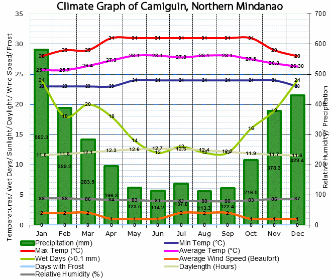
We wanted escape the usual nasty weather at the end of the year in Camiguin. By experience we know, that almost every year December and January are grey and rainy. You do not believe? Check the climate diagram of Camiguin:
The green bars show the monthly perception. Here in the Philippines this means simply rain. In your country it might also mean snow. Snow? What’s snow? Ah, yes, this cold white cover for skiing. The upper three lines show the monthly maximum, average and minimum temperatures. At 24 degrees with a breeze, we look for our our long sleeves and long pants. You clearly see that the best months to visit Camiguin are from March to October.
“But there is always rain” you might say. Please read below the chapter “Local Exceptions”.
You find ten of these climate diagrams for the Philippines in our new climate page.
We finally decided to go to southern Vietnam and Cambodia. In 3 weeks we got wet only 3 times. Once in Ho Chi Minh City. It rained about 15 minutes. And twice in Siem Reap, where we got two short 5 minutes showers. You can find over 4000 worldwide climate diagrams on ClimaTemps.
Philippines Climate for Expatriates
Potential expatriates, short expats, would like to know the climate of their future residence in advance. If you have to come to the Philippines for your new job, you probably will have to settle around Manila or Cebu. If so, check whether you need an air-conditioner. It will be probably yes, because most professional expats come from rather fresh countries.
But if you do not need to work or want to retire, a look in the climate charts can help you to find the place that best suits your climatic preferences. On the sea shores it is always warm because the sea water stocks the energy even during winter. Inland or up in the mountains it can be very fresh – even cold. Unfortunately we couldn’t find a valid climate diagram of Baguio.
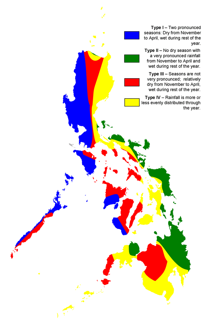
When the question comes to Leyte or Panay, then the following map might help:
Another interesting point for decisions where to settle might be the frequency of earthquakes. If you do not like to be shaken, have a look at this page.
Philippines Climate Exceptions
We already wrote that a climate is based on average values measured over many years. Climate information you can trust in most cases. But exceptions exist. There are 3 major exception: The micro-climate, the altitude and global effects.
Micro climates are climate deviations on small areas. A wonderful sample in Camiguin is the neighborhood of the Katibawasan falls. This almost 80m high waterfall creates a rain-forest climate. The sprays of the water make humidity raise to almost 100% all year over. The falling waters create very local winds that cool down the cove even on very hot summer days.

The altitude has a big impact on the temperature. When it is boiling hot in the lowlands, up in the hills and mountains it is always fresher, even cold. This means temperature decreases by 0.98°C per 1,000 m or 5.38 °F per 1,000 ft.
Another effect of the altitude (mountains) is the rain caused by the climbing air. On the windy side of the mountains you often encounter torrential rains, while the other side is dry and sunny. Again in Camiguin, compare Catarman and Agoho during AMihan and Habagat seasons.
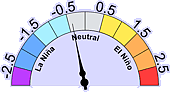
One of the most import global effects is the El Niño Southern Oscillation, or ENSO, Last year (2016), we met not one drop of rain from January to April. 4 months of drought are not common for our island, but it may happen. This last effect does not show up in the climate diagrams because El Niño and La Niña keep the balance.
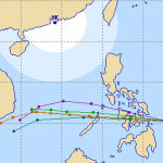
At this very moment (2017-02-06) we encounter a very low La Niña effect:
[GARD]
Related posts
 March 16, 2015 Tropical Storm BAVI weakens Tropical Storm BAVI weakens while maintaining its westward track towards the Philippines - heading for Luzon. Tropical Storm BAVI is […]
- January 21, 2015 More Milk for Camiguin Children "More Milk for Camiguin Children" has been announced by the Philippine Information Agency (PIA), Camiguin branch. More children get daily […]
- December 25, 2012 Tropical Storm WUKONG / Quinta is on forecast track Tropical Storm WUKONG / Quinta intensified again. It seems to keep "on-track" moving towards the central Visayas.
Forecast models show […]
- May 20, 2020 Bureau of Immigration prepares Digitization of Arrival Cards Bureau of Immigration prepares Digitization of Arrival Cards for Passenger Monitoring due to COVID-19
- December 12, 2019 Data Loss in the Tropics – Copy your Data to New Media Data Loss in the Tropics can happen the same way it occurs in the temperate zones of the earth. But there are two additional enemies: […]


Recent Comments