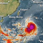
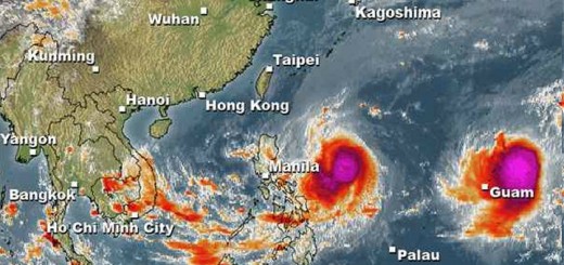
Cyclones KOPPU and CHAMPI moving west

The two Cyclones KOPPU and CHAMPI have both been upgraded to Tropical Storms. KOPPU/Lando is moving fast at 25 k/h while CHAMPI still hovers at 15 km/h. Both cyclones move west towards the Philippines.
The two Cyclones KOPPU and CHAMPI have intensified and have been upgraded to Tropical Storms. Cyclone KOPPU/Lando is now within PAR, the Philippines Area of Responsibility and is slowly intensifying. A northeasterly vertical wind shear (VWS) prevents a faster intensification. The sea surface waters are about 30 degrees Celsius. It is estimated that Cyclone KOPPU/Lando will be a typhoon Cat.3 or Cat.4 when hitting northern Luzon this weekend.
There is a small chance that Cyclone KOPPU/Lando will bend its track a bit more northwards. A deep subtropical ridge (STR) just north of the cyclone is strongly influencing its position. Depending of the northward outflow of this STR, Cyclone KOPPU/Lando may move more north or south. This outflow also influences the central pressure of the cyclone.
 |
 |
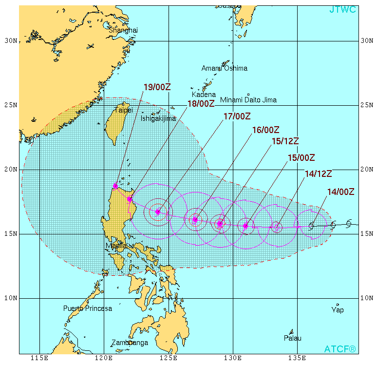
| Joint Typhoon Warning Center (JTWC) – click to enlarge | Japan Meteorological Agency (JMA) – click to enlarge |
Tropical Storm CHAMPI is not yet stable but its pressure is decreasing rather fast. We’ll start to track this second storm as soon as a reliable track forecast is possible.
KOPPU/Lando Storm data:
| Name (INTL. / local): | KOPPU/Lando |
| Class: | Tropical Storm |
| Time/Date of observation: | 08:45 AM on October 14, 2015 |
| Location of Center: | 15.9° North 136.4East |
| Moving Direction and Speed: | West @ 25 km/h |
| Moving towards: | Northern Luzon |
| Distance from the Philippines: | 1540 km E of Casiguran |
| Estimated Date / Time of Landfall: | n/a |
| Max. Wind Speed near Center: | 65 km/h |
| Peak Wind Gusts: | 93 km/h |
| Minimum Central Pressure: | 1000 hPa |
| Diameter: | 390 km |
| 24h Rainfall near Center: | n/a |
| Max. Wave Height: | 5 m |
| Here you find how to read and understand this data | |
Nearly real-time storm information
Next update this evening.
[GARD]
Related posts
 October 18, 2015 Too slow! Typhoon KOPPU/Lando creeps over land Too slow! Typhoon KOPPU/Lando moves only very slowly northwest. Forward speeds are between 3 and 9 km/h! The Typhoon continues to bring […]
- October 18, 2015 Landfall over Casiguran – Aurora Super Typhoon KOPPU/Lando has made Landfall between Baler and Casiguran in Aurora province around 01:00 a.m. this morning. Cyclonic winds […]
- October 17, 2015 Great Danger in Aurora – Typhoon KOPPU/Lando now Cat.4 Great Danger in Aurora - Typhoon KOPPU/Lando has now developed an eye and has been upgraded to Category 4. PAGASA has hoisted Storm SIgnal […]
- October 17, 2015 Typhoon KOPPU/Lando now Category 3 Typhoon KOPPU/Lando gained strength and is now a Typhoon Category 3. The cyclone has slowly approached the Philippines and is now 285 km […]
- October 16, 2015 Typhoon KOPPU/Lando is now affecting the Philippines Typhoon KOPPU/Lando is already near and upgraded to Cat.2. PAGASA sees it 510 km off the coast of Aurora. The strong winds and heavy […]


Recent Comments